Latitudes and Longitudes are used for specifying location of a point on Earth's surface.
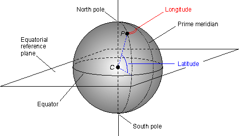
Latitudes are measured in respect of Equator. Equator itself is a latitude and is largest of all latitudes. The length of latitudes keeps decreasing as we move from equator to poles. It ranges from 0 degrees to 90 degrees (North and South). The latitude of any point on earth's surface can be known by measuring the angle b/w the line joining that point with Center of earth and the Equatorial Plane.
Longitudes are measured in terms of Prime Meridian. Prime meridian is a longitude which passes through Greenwich, England and is assigned with 0 degree. Other Longitudes are measured with respect to it in East or West direction. It ranges from 0 degrees to 180 degrees (East or west). The longitude of a point on earth's surface can be known by measuring the angular distance b/w the longitude containing the point and the Prime Meridian. All longitudes are of equal lengths.

International Dated Line(IDL):
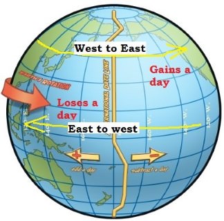
It is 180 degree longitude. As the earth rotates in west to east direction, places in eastern hemisphere will be ahead in time in r/o western hemisphere. For example, if it is 20/02/2018 in Eastern hemisphere, then it will be 19/02/2018 in western hemisphere. It means if someone crosses the International Date Line from East of IDL on 19/02/2018 to West of IDL he will lose one day i.e. he will reach West of IDL on 20/02/2018 and the day on 19/02/2018 will be skipped or lost. This can also be understood from the fact that it takes 24 hrs. for earth to complete one rotation along its axis. Which means if two points are at a distance of 360 degrees from one another there will be a difference of 24 hrs. b/w them. So, two nearby points on either side of International date line will experience a time difference of approx. 24 hrs b/w them.
Similarly, one day will be gained if someone moves from West of IDL to East of IDL.

Comments
Post a Comment