Geomorphology: Mountains

NOTE: Magma is molten rock below Earth's crust. Lava is magma that has reached the earth's surface.
A mountain is a large landform that stretches above the surrounding land in a limited area, usually in the form of a peak. Types of mountains:
1. Fold Mountains:
They are formed when two continental plates or one continental and one oceanic plate move towards each other at a convergent plate boundary. When the two plates collide the sedimentary deposits along the edges of Continental plates are forced to fold and hence folded mountains are formed. e.g. Himalyas.
Image result for fold mountains
2. Block mountains:
They are formed due to faulting. They are not true mountains as they are formed by differential settlement of land mass. There is no actual upliftment taking place as in case of fold mountains. Middle part of any land mass gets  lowered resulting into relatively raising of adjoining landmasses or Lowering of landmasses on either sides resulting into relatively raising of middle landmass. Block mountains are surrounded by faults on side of rift valleys or grabens. The uplifted part is called Horst and the depression is called Graben. e.g. Great African Rift valley.
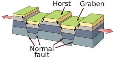
Image result for block mountains

3. Volcanic mountains:
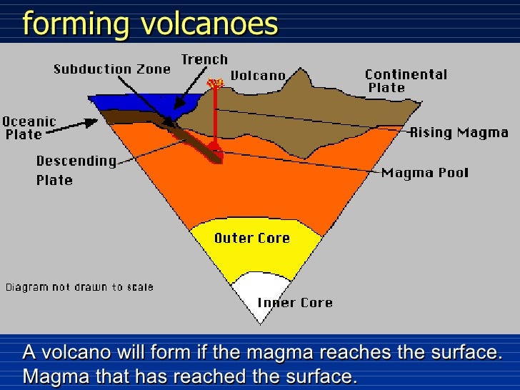
When a continental and an oceanic plates move towards each other at a convergent plate boundary, the oceanic plate subduct beneath continental plate because oceanic plate is denser. Due to high temperature below continental crust the oceanic plate melts and turns into magma. This magma is forced to come to the surface. When this magma reaches the earth's surface it cools down it formsrocks and eventually form Volcanic mountains. e.g. Mt. Fiji in Japan.
Related image

4. Dome mountains:
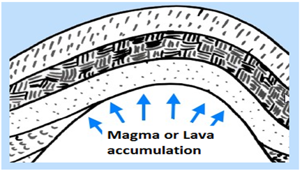
Formed when molten rock or magma pushes its way up under earth's crust. The magma does not erupts to the earth's surface but just pushes up the overlaying rock layers. e.g. Adirondack mountains of Australia.
Image result for dome mountainsImage result for dome mountains

5. Residual mountains:
They are formed from already existing mountains which are reduced by agents of denudation like water, air, ice etc. e.g. Mt. Monadnock in USA.
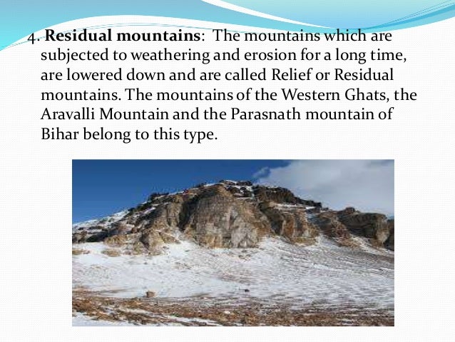
Image result for residual mountains


Comments

Popular posts from this blog

Tribes in India(Tricks to remember Tribes in India)

1. Andhra Pradesh: Andh, Sadhu Andh, Bhagata, Bhil, Chenchus, Gadabas, Gond, Goundu, Jatapus, Kammara, Kattunayakan, Kolawar, Kolam, Konda, Manna Dhora, Pradhan, Rona, Savaras, Dabba Yerukula, Nakkala, Dhulia, Thoti, Sugalis.  Trick to remember: Andhere Pradesh mein ek Nayak ki jaroorat hai. Jackie Chen(chenchus) Nayak( Kattunayakan) hai. Wo ek village se Sugandha(sugalis)  ko Kundi (konda) todkar horse pe Savari kar k Bhaga(Bhagata)  le gya to Village k Pradhan ne War(kolwar) shuru kar di kyuki Jackie Chen dusri Jati (Jatapus) k hai. Raste mein Jackie Chen ko ek Andha Sadhu   Dhoti (Thoti) pehne hue Dhul  (dhulia) mein gira hua milta hai. Andhe Sadhu ki kamar(Kammara)  mein dard tha jiski wajah se wo RONe  (Rona) laga. Jackie Chen ne apne DABBe (Dabba Yerukula) mein se  Bhel Nikal( Bhil, Nakkal)  kar Sadhu ko  khane ko di. Badle mein Sadhu ne Jackie Chen ko ek Kalam  (Kolam) gift ki aur  Mann(Manna Dhora) me...

Latitudes and Longitudes

Latitudes and Longitudes are used for specifying location of a point on Earth's surface. Latitudes are measured in respect of Equator. Equator itself is a latitude and is largest of all latitudes.  The length of latitudes keeps decreasing as we move from equator to poles. It ranges from 0 degrees to 90 degrees (North and South). The latitude of any point on earth's surface can be known by measuring the angle b/w the line joining that point with Center of earth and the Equatorial Plane. Longitudes are measured in terms of Prime Meridian. Prime meridian is a longitude which passes through Greenwich, England and is assigned with 0 degree. Other Longitudes are measured with respect to it in East or West direction. It ranges from 0 degrees to 180 degrees (East or west). The longitude of a point on earth's surface can be known by measuring the angular distance b/w the longitude containing the point and the Prime Meridian. All longitudes are of equal lengths. Internation...

Harappan Civilization

It was also known as Indus Valley Civilization (IVC). Harappan Civilization was of Indigenous origin which had gradually evolved. Initial communities of Mehrgarh etc. moved to fertile lands of Indus Valley. Surplus agriculture produce helped in development of other secondary activities. Gradually the population concentrated in the area leading to formation of Cities. Chalcolithic age helped in urbanization. Geographical extent of Harappan or IVC was as follows: In North- Manda in Jammu and Kashmir. In South- Diamabad in Maharashtra. In East- Alamgirpur in Uttar Pradesh. In West- Sutkagendor in Pakistan. Features of Harappan Civilization: 1. It was Indegenous. 2. It was urban and had urban institutions like citadel. 3. People were literate. Script was found however in could not deciphered yet. 4. It was an evolved society because means of entertainment like toys, chess, etc. found. 5. It was a multiclass society. There were artisans, merchants, traders, craftsmen etc. 6. ...